Machine Vision Detection Accuracy Across Deployed Remote Tower Systems
Fog and distant aircraft expose gaps that cameras and sensors struggle to reliably detect.
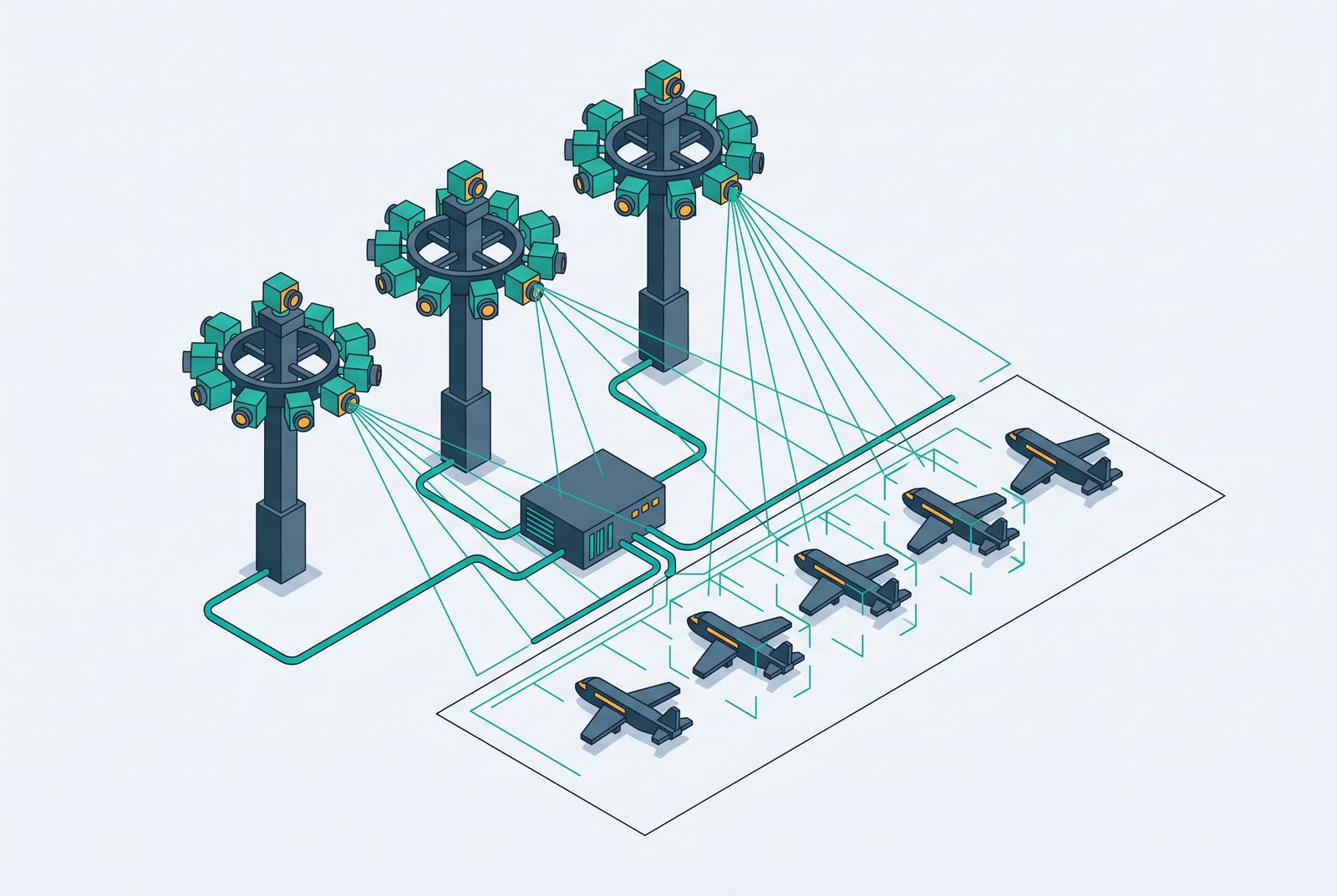
A remote tower system swaps the out-the-window view from a physical control tower for a set of cameras and sensors that rebuild the airport scene on a screen elsewhere. The sensor package typically includes high-definition pan-tilt-zoom cameras, infrared and thermal units for night and low-light work, and data overlays pulling from ADS-B, weather feeds, approach path indicators, and predictive tracking that projects where an aircraft is headed. This overlay approach draws on a system in which controllers work from a remote operations center, potentially hundreds of miles from the airport, with predictive tracking showing where an aircraft will be 30 seconds ahead. The controller sits in front of a panoramic display wall that reconstructs a full 360-degree view of the airport grounds, and the tower itself, if it still stands, can sit completely empty.
The controller sees a panoramic display wall recreating a 360-degree view of the airport, and the physical tower at the airport may be empty or absent entirely. Facing a costly renovation of its conventional tower, the airport abandoned the project altogether; the old tower stands unused now, and coordination for traffic at Saarbrücken runs out of the Remote Tower Centre in Leipzig. Scandinavian Mountains Airport, near Rörbäcksnäs in Sweden, took the idea a step further: opened in 2019, it was designed and built from the ground up with no tower structure at all, with remote control as the starting assumptionc4.
The financial logic driving these decisions runs on public money in the U.S. too. The FAA has put substantial funding behind procuring and deploying remote tower systems, betting on them as a cheaper way to bring traffic detection to rural and small community airports that could never justify a conventional tower build. No system has cleared FAA certification for operational use yet, and the rest of this piece works through what these systems can and cannot reliably see.
Why Machine Vision Detection Is Hard
Detection accuracy depends on conditions that are present during routine operations, not just during storms. Failure types recur across machine vision systems: missed detections, where something in the frame goes unflagged; false positives, where the system flags something that isn't there; and localization errors, where a target gets detected but its position on screen is wrong. Each carries a different cost. A missed detection is the most dangerous, since nothing alerts the controller to a hazard that's actually present. False positives erode a controller's trust in the system over months of use. Localization errors quietly poison the data overlays that are supposed to be the system's main advantage over unaided human vision.
None of this is exotic. Fog, heavy cloud cover, low contrast, motion blur, and cluttered backgrounds are routine conditions at working airports, and each one degrades machine vision performance in documented ways. Fog is the best-studied of the bunch. Light scattering under foggy conditions blurs images and distorts color, which drags down classification accuracy, localization precision, and the feature signals that detection algorithms depend on to tell one object from another. Standard detectors, including widely used YOLO-family architectures, fail to identify key traffic objects under fog, and the research literature treats that failure as a direct safety hazard rather than a cosmetic flaw. Recent work on aircraft detection in high-resolution optical remote sensing imagery shows how much civilian and defense applications depend on solving this same underlying problem. This is a property of how cameras capture light common to any company's software, so it applies to any optical system trying to see through reduced visibility.
Small objects at distance pose a separate, equally structural problem. Detection accuracy drops when targets suffer scale changes, irregular spacing, or dense obstruction, and remote sensing imagery compounds the issue by losing spatial detail whenever it's downsampled. Aircraft on final approach, runway vehicles seen from far away, and small drones all fall squarely into this category, and none of them are rare edge cases. They make up the everyday population of traffic that a small airport actually sees. Researchers developing multi-head attention dynamic sampling fusion networks for detecting objects in high-resolution remote sensing images have been working on this same class of scale and resolution problem. A target far from the camera occupies fewer pixels, and the same algorithms that perform well on large, close objects lose accuracy as the target shrinks against the frame, a geometric problem at its core.
How infrared and thermal sensors partially compensate for optical camera limits
Infrared and thermal cameras patch two of the biggest holes in optical detection, failure in low light and reduced visibility in fog, without closing the gap completely. Infrared sensors measure heat given off by a target rather than light reflected from it, so darkness doesn't blind them the way it blinds a standard camera. When a scene has too little visible light for an RGB camera to extract useful features, infrared can still supply usable information. Thermal imaging also cuts through some fog, since heat signatures can register through certain kinds of atmospheric haze, though heavy fog still degrades even thermal performance.
That's why more systems now combine RGB and thermal channels rather than picking one. This is why deployed systems increasingly fuse RGB and thermal channels: the combined view covers failure modes that neither modality handles well alone. Full fusion architectures aren't standard equipment across every installed remote tower system yet, though. Many operational deployments still run optical cameras without the infrared layer that would compensate for their weak points, so the accuracy profile a given airport actually gets depends heavily on which sensors were installed and how well they're integrated into the system. That's a procurement decision as much as an engineering one, and it varies airport to airport.
What ADS-B Data Overlay Adds to Machine Vision
ADS-B overlay is the single feature that extends detection furthest beyond what cameras alone can manage, but the extension only reaches aircraft that broadcast a signal. The system layers ADS-B position data directly onto the camera feed, adding callsigns, positions, altitude, speed, and predictive tracking that shows where an aircraft is likely to be moments ahead. For any aircraft equipped to broadcast, the controller ends up with a hybrid picture: visual confirmation from the cameras paired with positional data that holds up regardless of fog, darkness, or glare. That predictive tracking piece, projecting a short interval into the future, gives controllers a form of situational awareness that camera feeds alone simply don't provide.
The coverage runs out exactly where the hazards get harder to predict. Unequipped aircraft, drones, ground vehicles, and wildlife wandering onto a runway all sit outside ADS-B's reach, and every one of them is a genuine hazard category at small airports. For those targets, detection falls back entirely on machine vision, and every optical and infrared limitation described above comes fully back into play. Drones are the sharpest version of this problem: small, fast, frequently unequipped, and increasingly common around the airspace of smaller airports, which puts them squarely into the detection category that machine vision handles worst. The two layers, cameras and ADS-B, are stronger together than either alone. But the seam between them, where one stops and the other has to carry the weight, defines the real limits of what a deployed system can actually see.
Where Deployed Systems Have Operated
The systems currently running live traffic cover a narrow slice of the airport landscape, and the conditions at those sites don't map cleanly onto the wider range of airports remote tower technology is meant to eventually serve. London City Airport became the first major international airport under full remote air traffic control in 2021. Its 50-meter tower carries sixteen high-definition cameras and sensors, with controllers watching the feed from a station in Swanwick, Hampshire, a deployment backed by heavy infrastructure and deep technical support.
Sweden moved earlier and has gone further. The first remote tower cleared to provide aerodrome air traffic services was approved in October 2014 and went into operation in April 2015, and Sweden now runs live traffic remotely across multiple airports as one of the field's operational leaders. Norway's Avinor runs a similar multi-airport setup, standing alongside Sweden as the other Scandinavian leader in this space. Scandinavian Mountains Airport remains the clearest greenfield case: built without a tower from day one, rather than converted from an existing manned facility. Saarbrücken in Germany represents the cost-substitution case in practice rather than in a lab, a live deployment born from abandoning a tower renovation rather than a pilot program built to test the concept.
The U.S. picture looks thinner. Fort Collins–Loveland Airport in Colorado was selected by the FAA as a pilot and test site for a remote tower beginning in 2015, but no FAA authorization for operational use was granted there. Leesburg Executive Airport in Virginia became the first U.S. remote tower actually authorized to operate, running from 2015 to 2023, notable as a first but not yet a template other airports have followed. At Atlantic City International, the FAA has been testing a system as of May 2025 without certifying it for use in the National Airspace System. RTX is currently the only vendor with a System Design Approval in progress, and that approval isn't expected before September 2026.
The Scandinavian systems run through winter conditions, short daylight, snow cover, low contrast, that stress machine vision in well-documented ways, so their operating record says something real about how a layered sensor approach holds up against genuine adverse weather. Certification under those conditions means the systems have shown accuracy sufficient for the traffic types and conditions those specific airports present, not that detection accuracy has no limits. Scandinavian certification conditions and the conditions at a rural U.S. airport aren't the same, and that gap matters when anyone tries to generalize from one to the other.
Why the Accuracy Gap Matters at Airports With No Tower
The airports where detection accuracy carries the most weight are the ones with no detection capability of any kind right now. The United States has hundreds of towered airports compared with tens of thousands of non-towered landing facilities, and the vast majority of the National Airspace System operates without any form of structured traffic detection. Many of these airports don't even report runway incursions, simply because there's no tower present to collect that data in the first place, which means the official safety record almost certainly understates how often near-misses actually happen.
The hazards at these fields are neither rare nor mild. Opposing-direction traffic conflicts, VFR departures crossing paths with ILS approaches, and a mixed bag of corporate jets, student pilots, helicopters, and gliders sharing the same uncontrolled airspace all represent documented safety complexity that goes entirely unmonitored today.
A machine vision system with real, measurable limits still watches the runway, unlike having nothing there. But the accuracy floor still matters, because a system that fails under fog or struggles to pick out a small aircraft on final approach can fail at precisely the moment intervention would matter most. The real question for any given airport is what level of accuracy, under what weather and traffic conditions, turns a remote tower system into a genuine safety improvement over an uncontrolled field, and that answer shifts depending on each airport's own traffic mix, climate, and surrounding terrain.
The policy and certification environment that shapes what gets deployed and where
Technical capability alone doesn't decide what accuracy profile an airport ends up with. Certification does, and on that front the FAA has fallen behind both the pace of the technology and its own policy mandate to define standards for it. The FAA Reauthorization Act of 2024 directed the agency to build a clear system design and operational approval process for remote and digital towers, complete with testing and deployment milestones. As of the research behind this piece, the FAA still hadn't published a system design approval for a single project.
RTX remains the only vendor with a System Design Approval in progress as of May 2025, with approval not expected until September 2026, which leaves the U.S. market without a baseline certification standard against which accuracy requirements can be formally measured. Recent coverage has described the FAA as unenthusiastic and inconsistent in pushing remote tower certification forward, a structural delay that shapes which systems airports can actually access and on what timeline.
The Digital Tower Technology Coalition is pushing to speed up the policy and standards process, though that work remains in progress rather than finished. Until certification catches up, the technical question of how accurately a system can detect a plane in fog or a deer on a runway stays tangled up with a separate, slower-moving question: which systems the FAA will actually let an airport install.